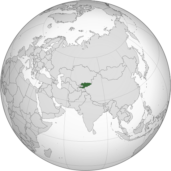
Файл:Kyrgyzstan (orthographic projection).svg
Appearance

Size of this PNG preview of this SVG file: 553 × 553 pixels. нэгъуэщӀ разрешенэхэр: 240 × 240 pixels | 480 × 480 pixels | 768 × 768 pixels | 1,024 × 1,024 pixels | 2,048 × 2,048 pixels.
Файлым и къежьапӀэр (SVG файл, номиналу 553 × 553 пиксел, файлым и инагъыр: 346 KB)
Файлым и тхыдэ
Махуэ/зэманым тепӀытӀэ файлыр дапщэщ сыт хуэдэу щытами уеплъынумэ
| Махуэ/Зэман | КӀэщӀу | инагъыр | ЦӀыху хэтыр | Гу зылъытапхъэ | |
|---|---|---|---|---|---|
| иджы екӀуэкӀыр | 04:08, 31 Бадзэуэгъуэ 2023 |  | 553 × 553 (346 KB) | Cutlass | rv sock edits |
| 19:09, 6 Мэкъуауэгъуэ 2023 |  | 553 × 553 (310 KB) | Cutlerys | Reverted to version as of 12:34, 4 August 2013 (UTC) | |
| 19:08, 6 Мэкъуауэгъуэ 2023 |  | 553 × 553 (306 KB) | Cutlerys | Reverted to version as of 23:39, 16 March 2015 (UTC) | |
| 21:17, 1 Накъыгъэ 2016 |  | 553 × 553 (346 KB) | Nicolay Sidorov | ... | |
| 02:39, 17 Гъатхэпэ 2015 |  | 553 × 553 (306 KB) | Flappiefh | Removed Somaliland and Kosovo. Separated Western Sahara and Morroco. | |
| 15:34, 4 ШыщхьэӀу 2013 |  | 553 × 553 (310 KB) | Flappiefh | Added South Sudan. The map is now centered on Kyrgyzstan. | |
| 19:02, 9 Бадзэуэгъуэ 2012 |  | 550 × 550 (490 KB) | Hariboneagle927 |
Файлыр къэгъэсэбэпын
Мы напэкӀуэцӀыр 1 тохьэ мы файлым:
Куэд къызэщӀиубыдэфыу файлыр къэгъэсэбэпын
Мы файлыр мыпхуэдэ викихэм къыщагъэсэбэп:
- Къыщыгъэсэбэпын ady.wikipedia.org
- Къыщыгъэсэбэпын af.wikipedia.org
- Къыщыгъэсэбэпын ami.wikipedia.org
- Къыщыгъэсэбэпын ar.wikipedia.org
- Къыщыгъэсэбэпын as.wikipedia.org
- Къыщыгъэсэбэпын av.wikipedia.org
- Къыщыгъэсэбэпын azb.wikipedia.org
- Къыщыгъэсэбэпын bcl.wikipedia.org
- Къыщыгъэсэбэпын bew.wikipedia.org
- Къыщыгъэсэбэпын bg.wikipedia.org
- Къыщыгъэсэбэпын bh.wikipedia.org
- Къыщыгъэсэбэпын bi.wikipedia.org
- Къыщыгъэсэбэпын blk.wikipedia.org
- Къыщыгъэсэбэпын bn.wikipedia.org
- Къыщыгъэсэбэпын ca.wikipedia.org
- Къыщыгъэсэбэпын cdo.wikipedia.org
- Къыщыгъэсэбэпын ceb.wikipedia.org
- Къыщыгъэсэбэпын cs.wikipedia.org
- Къыщыгъэсэбэпын da.wikipedia.org
- Къыщыгъэсэбэпын dtp.wikipedia.org
- Къыщыгъэсэбэпын el.wikipedia.org
- Къыщыгъэсэбэпын en.wikipedia.org
- Къыщыгъэсэбэпын en.wikinews.org
- Къыщыгъэсэбэпын eo.wikipedia.org
- Къыщыгъэсэбэпын es.wikipedia.org
- Къыщыгъэсэбэпын fa.wikipedia.org
- Къыщыгъэсэбэпын fi.wikipedia.org
- Къыщыгъэсэбэпын fo.wikipedia.org
- Къыщыгъэсэбэпын frr.wikipedia.org
- Къыщыгъэсэбэпын fr.wikipedia.org
- Къыщыгъэсэбэпын fr.wiktionary.org
- Къыщыгъэсэбэпын gag.wikipedia.org
Еплъын глэбальнэу къызэрагъэсэбэп мы файлыр.

