
Файл:Odisha locator map.svg

Size of this PNG preview of this SVG file: 607 × 600 pixels. нэгъуэщӀ разрешенэхэр: 243 × 240 pixels | 486 × 480 pixels | 778 × 768 pixels | 1,037 × 1,024 pixels | 2,074 × 2,048 pixels | 2,269 × 2,241 pixels.
Файлым и къежьапӀэр (SVG файл, номиналу 2,269 × 2,241 пиксел, файлым и инагъыр: 211 KB)
| Title |
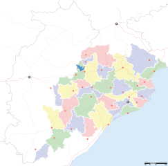
Orissa locator map |
||
| Description |
Locator map for the Indian state of w:Orissa. Equirectangular projection - Geographic limits of the map: top=24.27, bottom=17.691 |
||
| Махуэр | |||
| КъежьапӀэр |
Уней лэжьыгъэр |
||
| Creator |
|
||
| Хуитыныгъэхэр (Иджыри зэ файлыр къэгъэсэбэпын) |
I, the copyright holder of this work, hereby publish it under the following license: Мы файлыр лицензиекӀэ уогъуэт Creative Commons Attribution-Share Alike 3.0 Unported
|
||
| Geotemporal data | |||
| Date depicted | second half of 20 century икӀи 21 century | ||
| Georeferencing | If inappropriate please set warp_status = skip to hide. | ||
| Archival data | |||
| Notes | Part of WikiProject India Maps | ||
Файлым и тхыдэ
Махуэ/зэманым тепӀытӀэ файлыр дапщэщ сыт хуэдэу щытами уеплъынумэ
| Махуэ/Зэман | КӀэщӀу | инагъыр | ЦӀыху хэтыр | Гу зылъытапхъэ | |
|---|---|---|---|---|---|
| иджы екӀуэкӀыр | 20:28, 6 ФокӀадэ 2008 | | 2,269 × 2,241 (211 KB) | Planemad | |
| 16:28, 21 Мазае 2008 |  | 647 × 564 (132 KB) | Mkeranat~commonswiki | {{Information |Description=Locator map for the state of [w:Orissa] updated to show white borders for districts |Source=self-made, based on India locator map by [w:User:Planemad] |Date=Feb 2008 |Author= Mkeranat |Permission= |other_versions= }} | |
| 00:32, 15 Мазае 2008 |  | 647 × 564 (130 KB) | Mkeranat~commonswiki | {{Information |Description=Locator map for the state of [w:Orissa] |Source=self-made, based on India locator map by [w:User:Planemad] |Date=Feb 2008 |Author= Mkeranat |Permission= |other_versions= }} |
Файлыр къэгъэсэбэпын
Мы напэкӀуэцӀыр 1 тохьэ мы файлым:
Куэд къызэщӀиубыдэфыу файлыр къэгъэсэбэпын
Мы файлыр мыпхуэдэ викихэм къыщагъэсэбэп:
- Къыщыгъэсэбэпын ar.wikipedia.org
- Къыщыгъэсэбэпын as.wikipedia.org
- Къыщыгъэсэбэпын awa.wikipedia.org
- Къыщыгъэсэбэпын ba.wikipedia.org
- Къыщыгъэсэбэпын ceb.wikipedia.org
- Къыщыгъэсэбэпын de.wikipedia.org
- Къыщыгъэсэбэпын en.wikipedia.org
- Къыщыгъэсэбэпын es.wikipedia.org
- Къыщыгъэсэбэпын fa.wikipedia.org
- Къыщыгъэсэбэпын gu.wikipedia.org
- Къыщыгъэсэбэпын hi.wikipedia.org
- नलबण पक्षी अभयारण्य
- साँचा:ओड़िशा के लोकसभा निर्वाचन क्षेत्र
- आस्का लोक सभा निर्वाचन क्षेत्र
- भुवनेश्वर लोक सभा निर्वाचन क्षेत्र
- बलांगिर लोक सभा निर्वाचन क्षेत्र
- कटक लोक सभा निर्वाचन क्षेत्र
- ढेंकानाल लोक सभा निर्वाचन क्षेत्र
- जगतसिंहपुर लोक सभा निर्वाचन क्षेत्र
- जाजपुर लोक सभा निर्वाचन क्षेत्र
- कलाहांडी लोक सभा निर्वाचन क्षेत्र
- कंधमाल लोक सभा निर्वाचन क्षेत्र
Еплъын глэбальнэу къызэрагъэсэбэп мы файлыр.